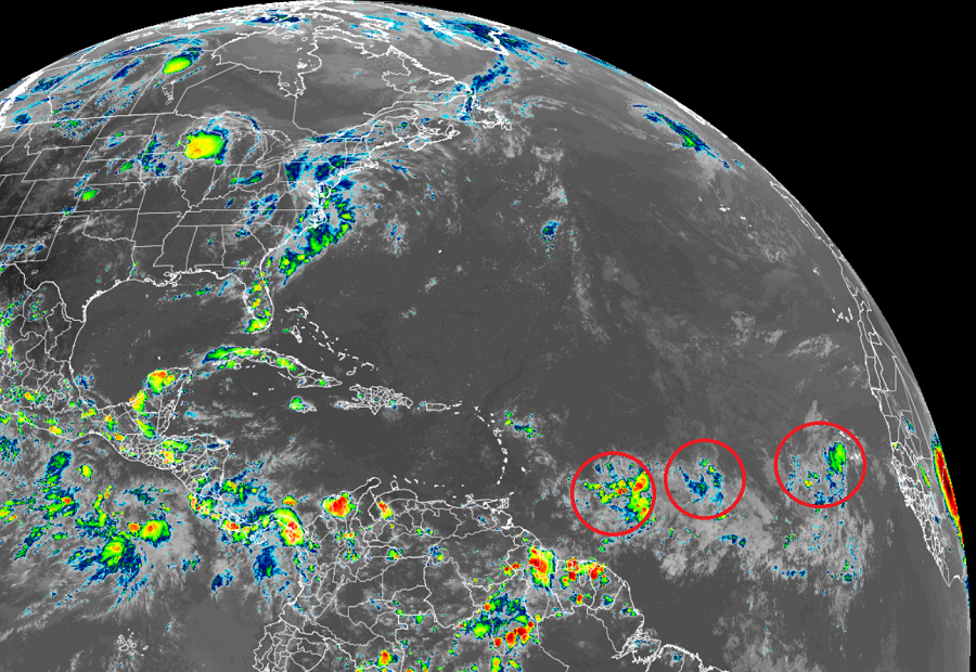
As hurricane season peaks in the Atlantic, the National Hurricane Center (NHC) has initiated monitoring of a weather disturbance that may develop into a tropical system. This system, currently located several hundred miles east of the Lesser Antilles, presents the possibility of significant weather impacts in the coming days. Forecasts indicate that the disturbance has favorable conditions for development, leading to heightened interest and caution among residents in coastal areas.
What disturbance is the National Hurricane Center currently monitoring?
The disturbance, labeled Invest 99L, exhibits increasing organization and convection. The NHC has indicated that environmental conditions are conducive for its development, suggesting that a tropical depression could form within the next 48 hours. As of the latest advisory, the system shows a 70% chance of developing into a tropical cyclone in the next five days.
Current Status of Invest 99L
Invest 99L is characterized by a broad area of low pressure accompanied by disorganized thunderstorms. The NHC reports that the system is moving west-northwestward at approximately 15 mph. Here’s the most recent data regarding the disturbance:
| Parameter | Current Status |
|---|---|
| Location | 820 miles east of the Lesser Antilles |
| Movement | West-northwest at 15 mph |
| Chance of Development | 70% within the next 5 days |
| Maximum Sustained Winds | 25 mph (40 km/h) |
Meteorologists are closely monitoring various factors that may influence the development of this system, including sea surface temperatures, upper-level winds, and moisture availability. Presently, water temperatures in the region hover around 80°F, which is typically sufficient for tropical cyclone formation.

Forecast Models and Predictions
The guidance from various numerical models reflects an opportunity for strengthening as Invest 99L approaches the Caribbean islands. Most models suggest that this system could gain intensity by the time it reaches the eastern Caribbean, with some predictions indicating potential hurricane status.
| Model | 48-Hour Prediction | 5-Day Prediction |
|---|---|---|
| GFS (Global Forecast System) | Tropical Depression | Category 1 Hurricane |
| ECMWF (European Centre for Medium-Range Weather Forecasts) | Weak Tropical Storm | Strong Tropical Storm |
| HWRF (Hurricane Weather Research and Forecasting Model) | Moderate Strengthening | Category 2 Hurricane |
As seen in the table above, forecast models indicate a range of possibilities, from minor development to potential hurricane status. This variability reflects the complexities involved in predicting tropical systems accurately. Meteorologists advise that forecasts can change rapidly, especially as the system nears land.
Impacts and Precautions
While the exact path and intensity of the disturbance remain uncertain, it is crucial for residents in vulnerable areas to stay informed and prepared. The NHC has outlined essential safety measures and preparations that individuals and families should consider:
- Emergency Kits: Ensure that emergency kits are stocked with essentials such as food, water, medications, and first-aid supplies.
- Evacuation Plans: Familiarize yourself with local evacuation routes and have a plan in place in case conditions worsen.
- Stay Informed: Regularly check updates from the National Hurricane Center, local meteorological services, and community alerts.
- Secure Property: Take steps to secure outdoor furniture, vehicles, and other items that could become projectiles in high winds.
Historical Context
September marks the peak of the Atlantic hurricane season, a time when the NHC typically monitors multiple disturbances. To provide context, here are statistics on prior hurricane seasons during this month:
| Year | Notable Storms | Total Storms | Hurricanes |
|---|---|---|---|
| 2021 | Hurricane Sam | 21 | 7 |
| 2020 | Hurricane Laura | 30 | 13 |
| 2019 | Hurricane Dorian | 18 | 6 |
The data above illustrates the variability in storm activity each year. Recent seasons have shown an increasing trend in the frequency and intensity of tropical cyclones, warranting an ongoing focus on preparedness and awareness.
Conclusion
While the National Hurricane Center closely monitors the disturbance currently labeled Invest 99L, residents in coastal areas should prioritize preparation and stay alert to updates. The potential for development into a tropical system raises significant concerns, especially as we approach the height of hurricane season.
As meteorologists continue to analyze data and offer timely updates, communities must remain vigilant. Remember, understanding the dynamics of these systems and following expert guidance can significantly mitigate risks associated with hurricanes and tropical storms.
Stay tuned for further advisories and updates as the situation with Invest 99L develops.

